


© A. Festa 2024-2026


Department of Earth Sciences
University of Torino, Italy
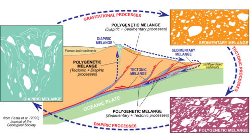
Mélanges and mélange forming processes
Definition of the role played by tectonic, sedimentary (gravitational), and diapiric processes
in the formation of mélanges (or chaotic rock units) in passive and active margins, and in
ancient accretionary complexes. Particular interest is addressed to document and define:
(i) the relationships between different mélange types, and geodynamic setting in which
they formed; (ii) the criteria helpful for distinguishing different types of mélange forming
processes and their superposition. This research is developed through the comparative
analyses of different types of mélanges exposed in the Apennines and W-Alps in Italy,
circum-Mediterranean region, Central Appalachians and Sierra Nevada (USA), Andean
Precordillera (Argentina) and Cantabria Zone (Spain). The paper "Mélanges and mélange-
forming processes: a historical overview and new concepts" by Festa et al. 2010
(International Geology Review, 52(10-12), 1040-1105) has been recognized as “High
Cited Paper” and evaluated the #10 paper on 11542 articles in the category “Geology”
of WEB OF SCIENCE for the period 2010 to 2014 (Web of Science Core Collection).


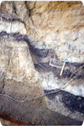
Advella Mélange (Pindos Mts.),
Greece (courtesy by Y. Dilek).
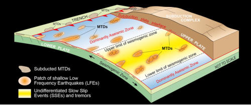
Convergent margins and subduction zones
Observations at modern convergent margins and accretionary wedge - subduction zone
systems throughout the world clearly show high degree of structural complexities and
variability in site-specific geometry, resulting in a complex segmentation along-strike as well
as along-dip. This research is devoted to the
definition of the structural setting and tectono-
stratigraphic evolution of convergent margins from subduction-related deformation to
collision and intra-continental deformation. It also focusses on the dynamics of the
accretionary complexes, including the study of the MTDs (mass-transport deposits) and
their control on seismic behavior of shallow-leve megathrusts at the subduction plate
interface, supported by the comparison between modern (ocean drilling from IODP
projects) and fossil analoques. Main studied areas are Apennines in Italy, Western Alps,
central Appalachians and northern Sierra Nevada in USA, and Crete in Greece.
Figure modified from Festa et al. (2018) - Gondwana Research 60, p. 186-193.
Intra-oceanic tectonic and sedimentation relationships

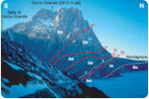
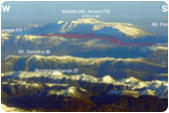
Sunrise at the Corno Grande
(Gran Sasso Renge, Central
Apennines, Italy). (
from Vezzani
et al., 2010 GSA Spec Paper
469)
Tectono-stratigraphic evolution of sedimentary basins
Definition of the geometry, and kinematic of faulting in the Apennines and Alps,
based on detailed structural analysis, and field mapping. Particular attention
has been addressed to the multistage reactivation of inherited faults, and their control on
sedimentation.
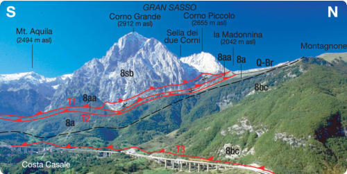
The photograph above shows the panorama on the northern frontal scarp of the Gran
Sasso thrust belt is modified (from Vezzani et al. (2010) - GSA Special Paper 469).

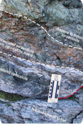
Overturned contact between
massive serpeninite, brecciated
serpentinite and talc-chlorite
schist within an exhumed
detachment fault (Monviso
Ophiolte, W-Alps;
from Balestro
et al., 2016, Episodes
)
Aerial view eastward of the
increasing uplift in the Central
Apennines carbonate platform
(Italy).
(from Vezzani et al., 2010
GSA Spec Paper 469)
Ankara Mélange, Turkey.
Geological Mapping
Geologic mapping
represents the
principal tool that I
use in my
research to
convey a
complete
compilation of
information about
the structure and
stratigraphy of the
sectors I work on.
It addition to
scientific papers,
the
product
consists of maps
at different scales
(from 1:10.000 to 1:250.000) of different sectors of the Apennines thrust-and-fold belt.
(see
“
).
Geological mapping is not always a
fundamental tool for my research, and I consider it integral to the professional development
of geoscientists, and particularly important as it applies to student understanding of spatial,
temporal, and complex relations in the Earth system.
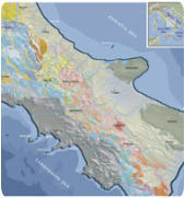
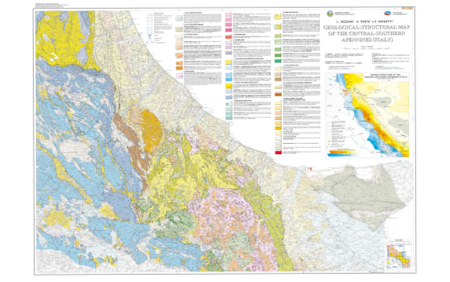
The Figure is Sheet 1 of the Geolgical-structural Map of the Central-Southern Apennines
(Italy) at 1:250,000 scale by Vezzani et al. (2010) - GSA Spec Paper 469

Structural scheme of Central -
Southern Apennines , Italy.
(from
Vezzani et al., 2010 GSA Spec
Paper 469)


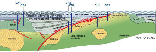
preserved remnants of extensional detachment faults associated to Ocean Core Complex
(OCC) in eclogite facies Western Alpine metaophiolite units. Particular attention is addressed
to the role played by preserved intra-oceanic structures in controlling the subsequent
tectonic evolution of Western Alps during subduction, obduction, collision and exhumation
stages.
Main studied areas are the Western Alps, Sierra Nevada in California,
and Crete. These studies have been awarded by IUGS (International Union of Geological
Sciences) with the
EPISODES Best Paper Award 2016
in recongition of the paper:
“Pre-Alpine extensional tectonics of a peridotite-localized Oceanic Core Complex in Late
Jurassic, High-Pressure Monviso Ophiolite (Western Alps)” by Balestro, G., Festa, A., Dilek,
Y., Tartarotti, P. Episodes, 38 (4), 266-282.
Figure modified from Balestro et al. (2016) - Episodes 38, p. 266-282.

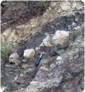
Normal fault in lacustrine
deposits (Sulmona basin, Central
Apennines, Italy).