


© A. Festa 2024-2026


Department of Earth Sciences
University of Torino, Italy
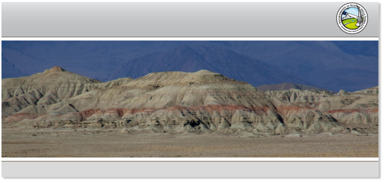
Geological mapping
and
production of maps
at different scales (from 1:10.000 to
1:250.000)
represent a significant activity in my research
.
I mapped different sectors of the Apennines thrust-and-fold belt working in different project
related to both research acivity, external funded projects and national geological project of
regional cartography (CARG project).
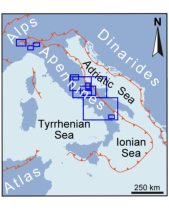
n. 14 Geological Maps has been realized (see
). Some of the most significant
and recently realized maps are listed in the following:

Blue squares indicate sectors of
the Apennines fold-and-thrust
belt mapped at different scales.
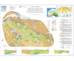
Geological Map of the External Ligurian Units in western Monferrato
(Tertiary Piedmont Basin, NW Italy).
Festa A., and Codegone G., 2013, Journal of Maps. doi:
10.1080/17445647.2012.757711. 1 Sheet (scale 1:10.000).
The Map, at 1:10,000 scale, describes in detail the tectono-
stratigraphic setting of the External Ligurian Units in the sector of
the Alps-Apennines junction. These Units consist of a Late
Cretaceous chaotic succession represented by the Argille varicolori
and the overlaying Monte Cassio Flysch. The late Eocene –
Miocene episutural succession of the Tertiary Piedmont Basin rests
unconformably on the External Ligurian Units. The mapped
crosscutting relationships between stratigraphic unconformities and
faults allow to describe a complex tectono-stratigraphic setting that
is the product of four tectonic stages.
See:
--------------------------------------------------------------------------------------------------------------------------------------------------------------
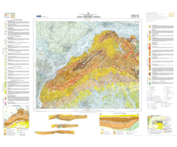
Carta Geologica d'Italia alla scala 1:50:000 - Foglio 156 "Torino Est”
Geological Map of Italy at 1:50,000 scale - Sheet 156 “Torino Est”
Festa A., Boano P., Irace A., Lucchesi S., Forno M.G., Dela Pierre F., Fioraso G., and Piana F., 2009, ISPRA,
Istiituto Superiore per la Protezione e Ricerca Ambientate. Ed. Litografia Geda, Nichelino (TO), 1 Sheet (1:50,000
scale).
This Geoological Map corresponds to Sheet n. 156 of the
Geological Map of Italy at 1:50.000 scale (CARG Project). It is
located at the northwestern termination of the Norhern Apennines,
in the Piedmont region close to Turin. It describes the tectono-
stratigraphic setting of the northern part of the Tertiary Piedmon
Basin, a late Eocene - late Miocene episutural basin resting
unconformbly onto both metamorphosed Alpine Units and
unmetamorphosed Northern Apennine Units (External Ligurian
Units).
See also
illustrative notes
: Festa A., et al., 2009, Note Illustrative della Carta Geologica d'Italia alla scala 1:50:000
- Foglio 156 "Torino Est". ISPRA, Istiituto Superiore per la Protezione e Ricerca Ambientate. Ed. Litografia Geda,
Nichelino (TO), 143 p.
Free download at: http://www.isprambiente.gov.it/Media/carg/note_illustrative/156_TOest.pd
---------------------------------------------------------------------------------------------------------------------------------------------------------------
--
Carta Geologica d'Italia alla scala 1:50:000 - Foglio 535 "Trebisacce”
Geological Map of Italy at 1:50,000 scale - Sheet 535 “Trebisacce”
Tortorici L. (Coord.)., Bianca M., Festa A., Mammino P., and Monaco C., 2009, ISPRA, Istiituto Superiore per la
Protezione e Ricerca Ambientate. Ed. S.El.Ca. Firenze, 1 Sheet (1:50,000 scale).
This Geoological Map corresponds to Sheet n. 535 of the Geological
Map of Italy at 1:50.000 scale (CARG Project). It is located in
Southen Italy, at the boundary between Calabria and Basilicata
regions, along the Ionian sea coast. The Map describes the tectono-
stratigraphic relationships between the North-Calabrian Unit, Sicilide
Unit and Mt. Pollino carbonatic platform Unit.
See also i
llustrative notes
: Monaco et al. (2009) - Note Illustrative
della Carta Geologica d'Italia alla scala 1:50:000 - Foglio 535
"Trebisacce". ISPRA, Istiituto Superiore per la Protezione e Ricerca
Ambientate. Ed. S.El.Ca. Firenze, 104 p.
Free download at: http://www.isprambiente.gov.it/Media/carg/note_illustrative/535_Trebisacce.pd
---------------------------------------------------------------------------------------------------------------------------------------------------------------
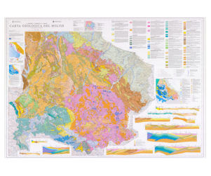
Carta Geologica del Molise
Geological Map of Molise
Vezzani L., Ghisetti F., and Festa A., 2004, Ed. S.El.Ca. Firenze. 1 Sheet (scale 1:100,000).
see
Festa A. Ghisetti F., and Vezzani L., 2006, Note Illustrative della Carta geolocia del Molise (Scala 1:100.000).
Ed. Litografia Geda, Nichelino (TO). 95 p. ISBN 88-902635-0-4.
The Geological Map of Molise at scale 1:100.000 completes
two decades of field research in the central Apennines. This
project has led to new cartographic coverage over a wide
area of several thousands of km square comprising the
outermost domains of the thrust belt. The Geological Map of
Molise covers a representative portion of the accretionary
wedge of the central Apennines, preserved in a structural
low. This area is dominated by the low-competence
successions of the far-traveled Sicilide thrust sheet
(Cretaceous-middle Miocene), thrusted over Mesozoic-
Tertiary carbonate units and over late Miocene siliciclastic
deposits telescoped with the carbonate substratum of the
Adriatic margin. Internal deformation of individual units is
heterogeneous, reflecting competence contrasts between sedimentary packages, large-scale rotation of units
during tectonic transport, and out-of-sequence propagation of thrust fronts. This system of tectonic units is largely
allochtonous above the buried Pliocene foredeep and Adriatic foreland, as testified by boreholes, seismic profiles
and gravimetry.
---------------------------------------------------------------------------------------------------------------------------------------------------------------


See:
-------------------------------------------------------------------------------------------------------------------------------------------------------------
Geological Map of the Villalvernia - Varzi Line between Scrivia and Curone valleys
(NW Italy).
Festa A., Fioraso G., Bissacca E., and Petrizzo M.R.,
2015, Journal of Maps, 11(1).
doi: 10.1080/17445647.2014.959569. 1 Sheet (scale
1:20.000).
In the northwestern part of Northern Apennines,
between Curone and Staffora Valleys, the tectonic
superposition between the External Ligurian Units (i.e.,
the ophiolitic-bearing chaotic complex of the Groppallo
Unit and the non-ophiolitic Cassio Unit), the Middle
Eocene – Miocene wedge-top basin Epiligurian Units
succession, and the Late Messinian – Pliocene Po Plain
succession, records the multistage tectono-stratigraphic
evolution from subduction to continental collision. Our geological map, at 1:20,000 scale, allows us to define six
main tectonic stages on the basis of (i) the crosscutting relationships between main faults and local to regional
stratigraphic unconformities, and (ii) the differentiation among different types of chaotic rock unit
(olistostromes and broken formations) deposited since Late Cretaceous to late Messinian. This approach provides
a new understanding on the tectono-stratigraphic evolution of this sector, and its meaning in the evolution of
the northwestern part of Northern Apennines.
See:
--------------------------------------------------------------------------------------------------------------------------------------------------------------
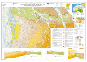
Geological Map of the Aventino River Valley (Eastern Majella, Central Italy)
Accotto C., Coscarelli F., Malerba E., Palazzin G., and Festa A., 2014, Journal
of Maps. doi: 10.1080/17445647.2014.899524. 1 Sheet (scale 1:25.000).
The Apenninic fold-and-thrust belt in Italy represents one of several
interconnected circum-Mediterranean orogens developed after the Late
Cretaceous – early Cenozoic closure of Tethys and convergence between the
European and African plates. The Geological Map of the Aventino River Valley,
at 1:25,000 scale, provides original mapping of the outermost sector of
Central Apennines in the Abruzzi region. Focusing on detailed mapping of the
crosscutting relationships between the main regional thrust faults and
tectonically driven stratigraphic unconformities, the map describes the
complex structural and stratigraphic relationships between the Outer Abruzzi
units (i.e. Porrara Unit), Apulia – Adriatic deformed units (i.e. Majella and
Casoli Units), and the allochthonous Molise and Sicilide units. These tectono-
stratigraphic relationships result from four main tectonic stages that occurred
sequentially over a short time interval from late Messinian to early Pliocene.
See:
--------------------------------------------------------------------------------------------------------------------------------------------------------------
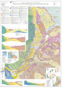
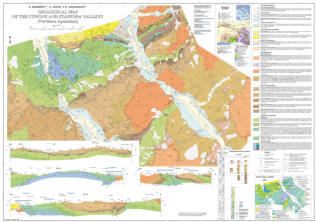
Geological Map of the Curone and Staffora Valleys (Northern Apennines, Italy)
Barbero, E., Festa, A., Fioraso, G., and Catanzariti, R.,
2017, Journal of Maps, 13(2).
doi: 10.1080/17445647.2017.1398114. 1 Sheet (scale
1:20.000).
The External Ligurian and Epiligurian Units in the
Northern Apennines of Italy are tectonically juxtaposed
with the Tertiary Piedmont Basin along the Villalvernia –
Varzi Line, which represents a regional scale fault zone,
E-striking. Our map, at 1:20,000 scale, describes the
tectono-stratigraphic evolution of this sector that
resulted from multistage faulting along that fault zone.
Four main tectonic stages are defined on the basis of
the crosscutting relationships between mapped faults
and stratigraphic unconformities: late Priabonian – Rupelian, Chattian – early Miocene, late Serravallian –
Tortonian, and late Messinian – early Pliocene. Our results demonstrate that since the late Burdigalian, the
Villalvernia – Varzi Line was sealed by the gravitational emplacement of a chaotic rock body. The deposition of
the late Serravallian – early Messinian succession is controlled by NW-striking strike-slip faults that crosscut to
the west the Villalvernia – Varzi Line. Extensional tectonics related to regional scale N-dipping tilting
characterized the late Messinian – early Pliocene time interval.

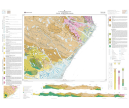
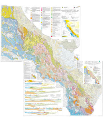
Geological-structural map of the Central-Southern Apennines, Italy.
Vezzani L., Festa A. and Ghisetti. F., 2010,
in
Vezzani et al. (Eds), Geology and Tectonic evolution of the Central-
Southern Apennines, Italy. Geological Society of America Special Paper 469, 58 p. ISBN 978-0-8137-2469-0. doi:
10.1130/2010.2469. 2 Sheets (1:250,000 scale).
The Geological-Structural Map of the Central-
Southern Apennines (Italy) provides entirely
revised and original cartography for a large
sector of the orogenic belt that stretches along
peninsular Italy. New data collected by the
authors over the past 20 years, together with
field revisions of published data, and available
subsurface data are synthesized in two
geological map sheets at scale 1:250,000 giving
a regional overview of the stratigraphy,
geometry, and structure of the Apenninic fold-
and-thrust belt. The Apennines comprise a
variety of lithotectonic assemblages that evolved
through interaction between the African and
European plates in the central Mediterranean,
with: (i) Mesozoic development of the Tethyan
domain; (ii) Cretaceous-Eocene oceanic
subduction; (iii) Oligocene-Miocene and
Pliocene convergence, continental collision and
shortening; and (iv) late Miocene–present
extensional collapse of the contractional edifice.
The geological maps and the Special paper
illustrate a number of critical orogenic
processes, including: (1) control of
paleogeographic position and stratigraphy on the fi nite geometry of the thrust belt; (2) the history of progressive
deformation and translation of far-traveled tectonic units; (3) selective reactivation of inherited structures during the
sequence of superposed tectonic events; (4) the evolution of syntectonic and posttectonic sedimentary basins; and,
(5) the propagation paths of thrust faults. The paper, together with the geological map and cross sections, provide a
regional overview of the progressive tectono-stratigraphic evolution of the thrust belt, with focus on the geometry of
the imbricate wedge and its subsurface geometry. Emphasis is also given to the relationships between active
faulting and historical seismicity.
--------------------------------------------------------------------------------------------------------------------------------------------------------------